 INR
INR GBP
GBP CNY
CNY EUR
EUR JPY
JPY MYR
MYR ZAR
ZAR KRW
KRW THB
THB USD
USDFrost Radar™: Downstream Geospatial Services, 2021
Frost Radar™: Downstream Geospatial Services, 2021
A Benchmarking System to Spark Companies to Action - Innovation that Fuels New Deal Flow and Growth Pipelines
23-Feb-2022
Global
Frost Radar
₹413,173.53
Special Price ₹309,880.15 save 25 %
Description
Geospatial technology incorporates historical and near-real-time mapping and surveying, remote sensing, aerial photography, global positioning system (GPS), and geographic information system (GIS) data so that downstream providers can offer navigation, connectivity, and location-based services.
While geospatial services revenue dropped at the start of the COVID-19 pandemic, government clients continued to invest in critical infrastructure monitoring and healthcare services. GIS mapping and GPS tracking, in fact, quickly demonstrated their value as health officials around the world used both along with specially developed apps to track the virus’s spread, perform contact tracing, and alert people about possible exposure. Esri, for example, created an interactive platform to monitor and track COVID-19 cases and vaccine distribution in real time. Healthcare agencies used ArcGIS Online to track active cases and deaths.
Urban utility system and remote pipeline inspections, digital mapping for public services, disaster response, investigations of the impact of climate change, and the development of fully autonomous vehicles all will rely on geospatial services. Frost & Sullivan estimated global market revenue in 2020 at $33.62 billion and projects a 2.5% compound annual growth rate through 2030. Government/infrastructure, operational and asset management, and natural resource monitoring services will be in highest demand.
Downstream providers must be able to offer user-friendly products and end-to-end services that include raw and processed image data, integration platforms, analytics, and IT infrastructure (developer tools). Start-ups that offer unique services and business models create new growth opportunities and could help established geospatial services players sustain growth through partnerships.
The Frost Radar™ reveals the market positioning of companies in an industry using their Growth and Innovation scores as highlighted in the Frost Radar™ methodology. The document presents competitive profiles on each of the companies in the Frost Radar™ based on their strengths, opportunities, and a small discussion on their positioning. Frost & Sullivan analyzes hundreds of companies in an industry and benchmarks them across 10 criteria on the Frost Radar™, where the leading companies in the industry are then positioned.
RESEARCH: INFOGRAPHIC
This infographic presents a brief overview of the research, and highlights the key topics discussed in it.Click image to view it in full size
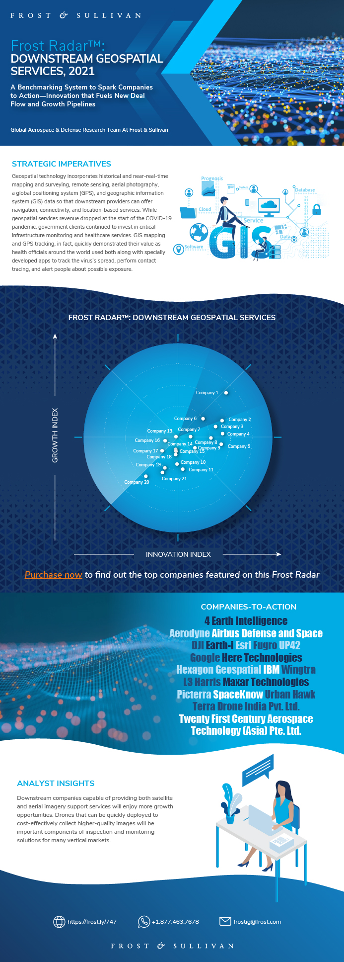
Table of Contents
Strategic Imperative
Growth Environment
Frost Radar™: Downstream Geospatial Services
Frost Radar™: Competitive Environment
4 Earth Intelligence
Aerodyne
Airbus Defense and Space
DJI
Earth-i
Esri
Fugro
Here Technologies
Hexagon Geospatial
IBM
L3 Harris
Maxar Technologies
Picterra
SpaceKnow
Terra Drone India Pvt. Ltd.
Twenty First Century Aerospace Technology (Asia) Pte. Ltd.
UP42
Urban Hawk
Wingtra
Strategic Insights
Significance of Being on the Frost Radar™
Frost Radar™ Empowers the CEO’s Growth Team
Frost Radar™ Empowers Investors
Frost Radar™ Empowers Customers
Frost Radar™ Empowers the Board of Directors
Frost Radar™: Benchmarking Future Growth Potential
Frost Radar™: Benchmarking Future Growth Potential
Legal Disclaimer
Popular Topics
| Deliverable Type | Frost Radar |
|---|---|
| No Index | No |
| Podcast | No |
| Author | Priyanka Gopalakrishnan |
| Industries | Aerospace, Defence and Security |
| WIP Number | K68E-01-00-00-00 |
| Keyword 1 | Geospatial Solutions Market |
| Keyword 2 | Geographic Information System (GIS) |
| Keyword 3 | Geospatial Technology |
| Is Prebook | No |
| GPS Codes | 9000-A1 |